


MIZOEN

ORTAX
User
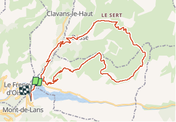

Length
28 km

Max alt
2263 m

Uphill gradient
1493 m
Km-Effort
48 km

Min alt
994 m

Downhill gradient
1467 m
Boucle
No
Creation date :
2019-01-15 12:29:34.4
Updated on :
2019-01-15 12:29:34.4
2h57
Difficulty : Unknown

FREE GPS app for hiking
 SityTrail
IGN / Geographical institutes
SityTrail Plus
The world is yours!
About
Trail Mountain bike of 28 km to be discovered at Auvergne-Rhône-Alpes, Isère, Les Deux Alpes. This trail is proposed by ORTAX.
Positioning
Country:
France
Region :
Auvergne-Rhône-Alpes
Department/Province :
Isère
Municipality :
Les Deux Alpes
Location:
Mont-de-Lans
Start:(Dec)
Start:(UTM)
274381 ; 4991828 (32T) N.
Comments